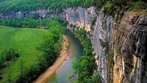
The Buffalo River, located in Northern Arkansas, was the first National River to be designated in the United States. The Buffalo River is 153 miles long. The lower 135 miles flow within the boundaries of an area managed by the National Park Service, where the stream is designated the Buffalo National River. The river flows through Newton, Searcy, Marion, and Baxter Counties, from west to east. The river originates in the highest part of the Boston Mountains of the Ozarks, flows out onto the Springfield Plateau near the historic community of Erbie, and finally crosses a portion of the Salem Plateau just before joining the White River. The Park is home to the state’s only elk herd. The upper section of the river in the Ozark National Forest is managed by the U.S. Forest Service and is designated as a National Scenic River and a National Wild River; that section is not part of the area managed as a park by the Park Service but is managed as a part of the Ozark National Forest. The Buffalo National River was established by an Act of Congress on March 1, 1972, ending the recurring plans of the U.S. Army Corps of Engineers to construct one or more dams on the river